Sunday, October 21, 2018

Jesuit missions of eastern Bolivia

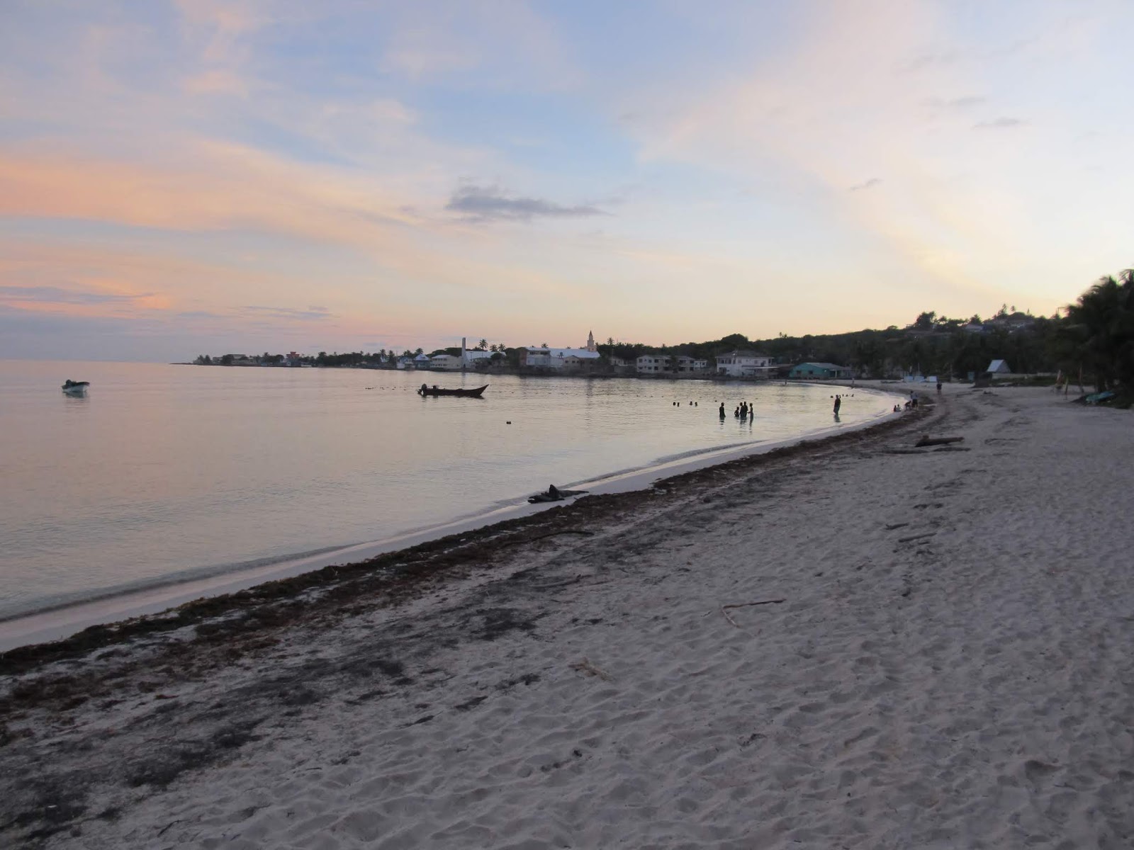
From Samaipata we returned to Santa Cruz for another night and the following day caught a bus heading east to San Jose de Chiquitos. It is a hot, dusty little town and one of the most accessible on the historic Jesuit Missions circuit of Bolivia. In the mid-1700's, Jesuit missionaries established a handful of missions in these inhospitable parts and the recently restored churches are a the main (or perhaps only) reason anyone visits the area. After an eye-rolling 4 hour ride on a bus that had water bottles holding open the door in lieu of air con and gag-inducing stenches coming from the on-board bathroom, we finally arrived. 40C and Sasha don't get along. I was happy to finally drop the humidity but the truth is we spent most of the time hiding in the coolness of our room. Night didn't cool things much but brought out a ton of flying beetles which covered the walls and bathrooms outside.
The streets are dusty, the traffic is.... well, lets just say tumbleweeds could consider it as a retirement destination. But the few people about were nice. It is cattle ranching country where it isn't just wilderness. I liked it though. The plaza was quiet but pleasant enough and the stone facade of the mission is pretty. We went inside to find ourselves in a courtyard. On one side was the church which we were able to see. Most of the structure is wooden, the pillars, roof, pulpit and carved crucifixions. Another side is a museum of sorts, maybe. There were signs for a ticket office and a route to follow around the mission and despite it being an "open" hour it was closed and nobody looked inclined to change that. I guess that's what happens when you are the only tourists in town. We've been seeing a lot of closed and unstaffed offices lately.

San Jose de Chiquitos
Lunch in the market
The San Jose Jesuit Mission


The following day we caught a morning trufi to San Rafael, another mission town 3 hours away on a bumpy dirt road. There were turn offs to the occasional farm or settlement but for the most part it was that same empty landscape, this time complete with the occasional Mennonite horse and buggy. The weather had started to cool and the forecast was for rain so we kept our eyes pointed skyward, willing the growing clouds to delay their deluge. (Our bags were busy getting dusty on the van roof and dust is way better than mud.) We almost made it but hit a quick rain storm and our bags now look like those of seasoned travelers ;)

Loading up the trufi in San Jose

Cowboys at work

We had just enough time for lunch in the dinky station before catching another trufi to San Ignacio. I was worried about the rain on my bag. I should've been worried about my bag in general. It turns out the second driver threw everyone's bags on the roof and took off without tying anything down. We made it only a few km before people in the back were yelling about lost luggage. My bag had bounced of the roof and into the bush on the side of the road. Fortunately it wasn't seriously injured but I lost its rain cover somewhere in the process.
San Ignacio was just under 2 hours away via a quick stop in San Miguel. San Miguel had a nice looking church right on the main plaza which we saw in passing. It has a more typical style of architecture for the missions in the area, completely different from the one in San Jose and more like what we were to see in San Ignacio.
San Ignacio is the hub town of the region. It is bigger than San Jose and by bigger I just mean more sprawled out so you actually need a mototaxi to get around.  Fortunately they seem to be ubiquitous in Bolivia, or at least in the Santa Cruz region. It has a nice mission church on the corner of a very large plaza where we relaxed and had our dinner, watching the mototaxis cruising around for business and the local teens wandering around. Everyone smiled and greeted us as they passed our outside table. It was quite relaxing and nice. Again, I like Bolivia a lot so far and it is a shame we had to keep moving forward so quickly.

The more representative style of the Jesuit missions, San Ignacio

Nice Plaza

The reason we came to San Ignacio (aside from the church) was to make the crossing to Brazil via a remote and little used border post at San Matias. We knew there were buses making the very long journey from Santa Cruz and that they would pass San Ignacio before continuing further so the plan was to jump on one of them and save ourselves a very long bus ride on bad roads by breaking it into parts. Turns out we were able to catch a bus as there were two a day, both passing through at 3 am! Ugh.  We learned that on arrival in San Ignacio so opted to rent a cheap room for 12 hours, visit the church, have dinner, take a nap and catch the bus. They weren't lying when the said the road is long and unpaved, but it really wasn't that bad. The bus made decent time and the seats went way back so you actually had a good position to sleep and the recent rains minimized the dust without making it so muddy it was a problem.  There are only a few very small villages between San Ignacio and San Matias so the landscape was mostly wild and surprisingly green. I managed to see a lot of different birds and even some wild pig and capybara out the window as we drove along. In only 6 hours we arrived in San Matias, earlier than I expected and we were lucky enough to be asked by a nice Bolivian lady if we wanted to share a taxi to the border (this is the way of getting across the no-man's land and we needed someone to adopt us anyway). With quick stops in town to get money changed and stamped out of Bolivia first, we drove quite a way before we got to the actual border and customs guards. Customs pretended to search our bags with a cursory glance and then we were free to go. And go we could, because there was suddenly a beautiful paved road, perfect right up to the line. After 500km of dirt, it was glorious. Only, there was nothing on the other side. No town, no bus stop, just a road and a much more agricultured (just let me make my own new words) landscape.
So our taxi kept driving. And driving. And we turned to the lady beside us and finally asked "where are you taking us?" Turns out the closest town is Caceres, nearly 100km away. At least someone knew what was going on and they drove us first to the Federal Police station where we had to get our entry stamp. Why they don't do it at the border I don't know. They didn't check our yellow fever vaccination either which I thought all the crossings into Brazil did. And then finally we were dropped off at the bus station in Caceres. The taxi was about $20 each. Beats walking... Had a quick lunch and jumped on a nice bus to Cuiaba, another 4hrs down the road, happy to have successfully crossed on a route that was very hard to get any recent info on.
Ammon

Santa Cruz and Samaipata, Bolivia

We made it in late to Santa Cruz on our flight so it wasn't until the next day that we got a chance to step outside and see what we had gotten ourselves into. Having talked to many people over the years about South America, Bolivia has continually been mentioned as a place that many people spent (or wish they had spent) longer in. Obviously there is something to the place, and I can honestly say that within the first hour of walking around Santa Cruz my inner travel soul finally woke up, looked around, stretched and said "now you have my attention". It might technically be the 7th country we've been to already on this trip but it finally feels like the beginning of something.
Santa Cruz is the biggest city in Bolivia with over 1 million people but still managed to feel like a small provincial capital, especially in the centre where we were. It is not the capital of the country and receives little love from the powers that be up in La Paz. There are also few tourist sites in town so while Bolivia is very popular on the "Gringo Trail", only a small percentage of visitors descend to the lowlands of the Santa Cruz region for any length of time.
What was nice for us is that we have finally left the Caribbean vibe and entered a Spanish one. Soaking up the atmosphere in a beautiful plaza in front of a colonial-style catholic church is the new time killer. Santa Cruz has a nice, very relaxed and family-oriented plaza without hassle where vendors in uniforms wheel thermoses of coffee and tea around for sale by the cup, little old ladies walk by in traditional dress and couples stroll hand in hand and (most shockingly of all) less than half of people were staring at their smartphones. Gasp! Could it be? In the big city? Something still resembling a traditional and authentic culture? And I haven't even started on the Mennonites yet.

Central plaza of Santa Cruz
Central Plaza

Los Pozos market area
Random park near our hotel in Santa Cruz

Decades ago the Bolivian government welcomed the first Mennonite settlers into the Santa Cruz region (mostly from Paraguay and Canada) and today there are dozens of farming colonies scattered about the state, not far from the city. Our hotel was in the Los Pozos market area and the area is full of Mennonite families in town for trade. Most in Bolivia are of a more conservative style and they were easily identifiable by their lighter skin and clothing. The men invariably wearing overalls and either white cowboy hats or plain ball caps, the women in long dresses and headscarves or wide-brimmed hats. It just wasn't what we were expecting to wake up to.
We were also pleasantly surprised to discover much more affordable prices in general (our hotel room was $10US), a well organized and easy to use city bus system and a relatively slow-speaking Spanish which we could sometimes understand. That Sasha could understand anyway. I still mostly suck at this other language thing...
After a day in Santa Cruz we caught a shared minibus (called a trufi) to Samaipata, a small town 2.5 hrs to the west and starting the climb up into the Andes. It sits just under 2000m so we felt the altitude a bit  and definitely felt the difference in temperature. After weeks at humid 30C+ temps, we were struggling to adjust to the teens.  It was warm while it was sunny but temperature probably played a factor in our not staying longer than 2 nights. It is a beautiful area and a popular one as well with a significant expat population and international traveler feel despite being so small. There are quite a few little restaurants, cafes, guesthouses and travel agencies within a couple minute walk of the central plaza. It was obviously the offseason though because most places were closed most of the time and opening hours/days seemed very random. It didn't matter because its just a nice place to take it easy and relax anyway.

Samaipata


Pretty setting of Samaipata

Our reason for being in Samaipata was to visit the El Fuerte ruins about 10km away. The ruins sit on top of a nearby hill with great views. There is still some mystery as to who originally made the site and its original purpose but it is definitely pre-Incan and possibly dates to 300 AD. The original site was apparently ceremonial and is a large carved rock with many niches and holes as well as faded carvings of geometric designs and animals. The Inca and later Spanish also used the area as a more administrative settlement or as a fort to watch over the local trade routes and some ruins (mostly rock walls and building bases) are present nearby from that time as well. As far at the site is concerned, it isn't overwhelmingly awesome but the views are great and it is well laid out with a set walking path and elevated viewing platforms to see the ruins without being able to actually touch/destroy them any further. A typical visit involves a taxi taking you and waiting for 2 hours while you go around the circuit. We finished a little quicker because there was hardly anyone else there.

El Fuerte

The dark carved stone is the old pre-Incan stuff. The lighter is Incan

Even the viewing walkway is kind of cool


Ammon

Monday, October 15, 2018

San Andres Island

Our last-minute change of plans had us flying out of Guyana with the ultimate goal of rejoining a point further down the road on our original route but saving a lot of overland hassle. There aren't a lot of flight options out of Guyana to begin with and last-minute ones are a good budget killer so we ended up using aeroplan points to get us out of there. The thing with points, they don't always take you where you want to go and it became obvious quickly that it was going to take 2 separate tickets to get us anywhere near where we wanted to end up. If you have to make a stopover somewhere anyway, I always vote for the most random spot to get your money's worth and so we found ourselves on Copa Airlines and an overnight in Panama City before continuing on to San Andres.
Panama City was a shock after Georgetown. The initial impression is of a big modern city of skyscrapers. It felt very comfortable. We didn't have any time to explore the city in detail but our visit marked a milestone in our first use of Uber. I like this Uber thing. Very convenient and affordable way of getting to/from the airport. Otherwise, we just slept and the next morning went to a nearby mall to find some things for Sasha. They had everything from home and more. No wonder it is a popular place for retirement. We didn't really find it any cheaper than home though. We are hoping to visit Panama again at the end of this trip so we'll get a more in depth perspective then.

Panama City on the right, canal on the left

I have to admit I didn't really know San Andres existed until quite recently. It is a small Caribbean island off the coast of Nicaragua but belonging to Colombia. How it became Colombian is a little complicated but historically it was British so English is an official language of the islands and a creole mix is spoken by the "real" islanders.  There has been an influx of mainland Colombians over the years which has changed the social demographics somewhat and "ruined" the island. Or so the host of our little B&B told us. San Andres is a duty-free port and a popular all-inclusive tourist destination for Colombians. Every visitor needs to pay for a special tourist card and get it checked on arrival and departure, it is currently about $36US each. In theory this helps preserve the unique culture of the island but change is inevitable and the traditional culture is slowly being replaced.
In a way it is a wonder the foreign tourists haven't discovered and developed the island yet.  The water is beautiful. There are many nice beaches on the island and a number of smaller islands and cays just offshore. Cheap boat tours are a big thing to do. We didn't bother since from the beach you could easily appreciate the multiple shades of clear blue warm already. Ok, maybe I was tempted to go diving, but didn't have the time to organize it.
We stayed near San Luis and its beach (about halfway down the island on the east side) as it is known to be a quieter and more "local" beach as well as one of the nicest.  We had 2 full days to kill and spent most of them walking and lounging on this beach. There isn't much in the way of development but there are a few small restaurant/beach bars, attached to small resorts. You can still get food, drinks, chairs, etc from them. There are even a few spots with little lockers though from the looks of things people were just leaving their stuff lying around and theft isn't a huge problem on that beach, at least for now... There were a few guys touting jet ski rides and kayak rentals. It was October off season and fortunately there weren't that many people around and the weather held despite a near constant risk of rain. Another popular thing to do is rent scooters or golf carts and drive around the island to visit all of the beaches and viewpoints. Off the beach it feels pretty rural as well with lots of chickens and lizards running around. The main city of San Andres looks pretty poor and rundown though and crime is supposed to be getting worse in that area.

Our B&B in a traditional home

Rural walk to the beach


Sunset and San Luis in the background.

Apparently there is another smaller island nearby call Providencia that is even more quiet and stunning, but a short additional flight or lengthy boat ride are required to get there. It is supposed to by much better and worth the effort if you have time to go. Maybe if there is a next time.
And as soon as it had begun we were getting ready to leave again with a flight via Panama again to Santa Cruz, Bolivia. I was going to say that I was pleasantly surprised by the quality on our Copa flights but I am too annoyed at the ladies that checked us in in San Andres.  They actually made us go into their back room and book an onward international ticket out of Bolivia before they would let us on the plane. We had to buy a nonsense international bus ticket (which was 80% refundable later) and this is the first time I wasn't able to talk my way onto a plane. Airlines are generally more uptight and strict about these things which is the most annoying part because of course Bolivian immigration didn't even question us at all on arrival.
Now we start the overland South America journey properly!
Ammon

Sunday, October 07, 2018

Suriname and Guyana

We flew from Trinidad to Suriname to finally hit the mainland and officially start the South American portion of the trip. The initial plan was to see what the Guianas are all about and when ready continue south into the Brazilian Amazon. Of course all that was to change but we didn't know that yet...
The Guianas are the 3 little "countries" on the north coast of South America that everyone forgets about, including the other South American countries.  This is in part because they aren't really connected to the rest of the continent, be it by land, air, history, language or culture. They are most closely aligned with the Caribbean or with their parent European country.  British Guiana = Guyana, Dutch Guiana = Suriname and French Guiana is still a French colony.
After looking at all the options, I ruled out a visit to French Guiana based on logistical hassle and expense.  From the sounds of it, French Guiana is the Fort Mac of France with very inflated prices and no infrastructure for independent tourism. The other ones aren't much better as we quickly found out.
Few travelers venture to the Guianas and those that do usually follow a quick and uniform route, aided by the fact that there is virtually only one road to take along the coast between all three. When we arrived in Suriname we spent our first night near the airport thinking to head further inland the next day, only to find out that none of the country's public transport passed further inland along that road. We continued to the capital, Paramaribo, and ended up crashing at a couchsurfer's place for a few days.  He was a cool old guy who travels a lot and always has a bunch of others staying with him as well. 
We were to make friends and swap stories with a few other traveling groups that had been in the area a little longer.  To summarize, what we learned was that unless we planned on bringing hammocks, and were open to hitchhiking and roughing it, we weren't going to get very far out here.  Oh, and these countries are on the sketchy side too so the wisdom of such an approach is questionable. As this is not intended to be THAT kind of trip, we ultimately decided to minimize our time in the area and start looking at other options.
Paramaribo was worth a visit though.  The historic centre of the city is Unesco-listed and mostly consists of historic wooden buildings, some restored, some abandoned and some just looking old. But the style is cool. They also have the largest wooden building in the western hemisphere in the St. Peter and Paul cathedral.  The church looks nice on the outside, recently restored and painted in soft colours, but the inside is unpainted and the natural wood is a very pretty and unique look for a catholic cathedral. There is also the small Fort Zeelandia along the river and although Paramaribo doesn't have the best reputation I felt fine walking around during the day, but a little less so along the waterfront.
Suriname is an interesting mix of people too.  African, East Indian, Amerindian, mixed-European.  There were a lot of different types of people to watch moving around. Interestingly, the shops all seem to be owned and run by Chinese now. Our immigration officer looked Filipino. With all this ethnic diversity comes a huge religious diversity too and one of the prides of Suriname is that they all coexist peacefully in that regard. There is a point in the centre where the largest mosque and largest synagogue in the country have been built side by side.

Mosque and Synagogue

St. Peter and Paul Cathedral
Presidential palace

Wow

Historic old town
Fort Zeeland

The fort overlooking the river

We left Suriname on a 4:30am minibus heading to Guyana a few days later. Suriname is, by percentage, the most forested country in the world, so between little villages there is a whole lot of nothing but greenery. Most of the homes we saw along the way were old, wooden and on stilts. We had a flat tire at sunrise and got to stand out on the side of the road listening to howler monkeys waking up as the tire was changed. The border of Suriname and Guyana is the Corentyne river with a ferry crossing the only way between them. As the only crossing it tells a lot about movement between them that there are maybe 2 crossing each way in a day and the ferry was full with maybe 2 dozen vehicles and a few dozen walk-ons. We took the little ferry and were picked up on the other side for the rest of the trip into Georgetown arriving in the early afternoon.

Getting on the ferry

Georgetown is not a nice city.  Once upon a time it was known as the city of gardens with lots of green space and streets lined with canals because most is actually a few feet below sea level. Now, the city is falling apart and unkempt, the canals are stagnant and smelly and everyone is paranoid about security.  Or maybe it isn't paranoid because the crime issue is real and even daytime muggings are becoming common. I'm not fond of places where the sun sets at 5:30pm and you shouldn't go out after dark. Taxis are even recommended during the day though if you do walk, don't carry anything valuable on you. I'm sure I've been in worse places, but we weren't interested in taking chances for a city we weren't very interested in in the first place.
So why were we here? Because there is no road to Brazil from Suriname for one thing, but that became a moot point when we decided we were going to reroute and fly out instead. Unfortunately in order to fly out we had to wait a bit and we ended up getting stuck in Georgetown for 4 nights. Most of the time we spent just hiding out and not venturing more than a couple blocks on foot to get food.  There are many nice people here, but at the same time, the city has a hostile vibe and doesn't feel very nice. Lots of people look at you kind of funny like you are being sized up for something.

Georgetown by our guesthouse

Killing time
Central Georgetown

One thing we ended up doing and had always planned to see here was Kaieteur.  It is the world's largest single drop waterfall and the biggest attraction in the country. There is no road to it so a land based trip to visit the falls is a 5-day epic journey through some rough but scenic conditions.  99% of visitors don't pick that option. The usual way to see the falls is on a day trip by plane and there are a few domestic airlines here that run the tours. It is an hour flight each way in a small plane (we were 9 in our group) with about 2 hrs on the ground at the falls. You get a nice view of the falls from the air and then meet up with a guide on the ground who introduces you to the local flora as you walk a trail to a series of viewpoints. The views are incredible.  The falls are 741 feet high and depending on the season can be up to 370 feet wide.  It is the combination of height, size and large volume of water that makes it so impressive and it is commonly listed in the top 10 of "best" waterfalls in the world.  It is the dry season now so we had a beautiful day and the falls are still impressive, but they were flowing at less than half their full capacity.
What makes the visit even more special is that it is so remote in a country rarely visited anyway that fewer than 100 people see it in a day. There were a few other planes scheduled to come in after us (we were the first flight of the day) so we were literally 10 people there viewing the falls.  No crowds, no mass marketing, no development nearby.  Just nature in all its glory. The viewpoints are the edge of the cliff nearby so it is kind of scary if you don't like heights and the views get progressively closer until at the end we actually got right up to the edge of the water. We loved it. Day trips run at $165US and up but there really isn't much choice if you want to see it.

Arrival at Kaieteur

Walking to the falls


Ammon

Friday, October 05, 2018

Tobago (and Trinidad)

Country #2 was Trinidad and Tobago, though we only stayed on the smaller, nicer island of Tobago. From Barbados we flew on LIAT via St. Vincent to Trinidad. The Grenadine islands south of St. Vincent look amazing and I can't wait to get there someday...
To get between the islands of Trinidad and Tobago there are 2 options.  A ferry between the two main cities of Port of Spain and Scarborough or a short flight. The flight is a domestic "air bridge" with hourly service on large turboprops at a set rate of $25US one-way. You don't have to worry about flight times and seat selection and if you really wanted could just show up at the airport and try standby. We had a connecting flight and gave ourselves too much time on our layover (to be on the safe side, especially when switching airlines) but fortunately, at no extra cost, they had extra seats on an earlier flight and we got to Tobago a little sooner than we expected.
Trinidad has a reputation as being a busy, crime-ridden, industrial island with very little tourism apart from its world-famous Carnival. Tobago on the other hand has a small tourism industry and is considered to be much safer and more laid back. The bulk of tourism is located at the southwest tip of the island, right beside the airport at Crown Point, where they have their nicest beaches and most amenities. It is the rainy off-season here too and after a quick look at "the strip" in Crown Point, it doesn't look like this is a huge booming tourist island in the Caribbean even at the busiest of times.
Tobago is still quite rural looking with chicken, goats and dogs wandering around people's yards or frequently on the side of the road, even in the towns.

Crown Point area

Typical around Tobago

We stayed a night in Crown Point because we arrived late and the next day took the bus (slow and inconvenient timetable but cheap) up to Castara via Scarborough. Locals will tell you that Trinidad = party and Tobago = chill. And Castara is very, very chill. This would be the closest thing you could find to a backpacker hangout town in Tobago, but, there were no backpackers.  There are a few older hippies and a handful of couples, but most of the plethora of accommodations are empty and many of the restaurants don't even bother to open every day. Castara's vibe is that of a fairly isolated fishing village set around a pretty bay that is divided into two unequal parts by a rocky outcrop. The sand is coarse and brown, unlike Barbados, but the more authentic local atmosphere more than makes up for it. Thick vegetation covers the steep hills leading up from the water and it was a sweaty 10 minute walk up the hill to our little guesthouse apartment.  We had great views but the workout necessitated a quick shower every time we came back home. You can swim, hike around, chat with the friendly locals or just relax and listen to the birds dropping mangoes out of the surrounding trees. We mostly opted to relax as the water was too rough for swimming and the weather would send periodic downpours on us throughout each day.

Castara beach

Castara


Little bay, Castara

There are a few bars right on the beach and they seem to take turns hosting weekly events (drumming sessions, bonfires, bbqs, etc). We went to see what the bonfire beach party was all about one night and as expected it was mostly locals with probably every tourist currently in the village in attendance.  Hassle-free, laid-back, rasta-ish, lots of drumming. We enjoyed seeing a real steel band playing as it is the local music that Trinidad is most famous for and has since spread throughout the region and world.
We walked up and down the hill and around the village.  We walked 3km or so to the isolated Englishman's beach for something else to do.

Englishman's Beach

Even more deserted than the others


We stayed 3 nights in Castara and on our last full day in Tobago, we checked out and were picked up by a local Couchsurfing guy, Kyle, and his girlfriend, who drove us in a complete circle around the island stopping off to see different points of interest, usually more beaches in more pretty bays.  Charlotteville at the far north end of Tobago was very pretty and we had a huge lunch on the beach at The Suckhole restaurant. It looked like a nice town to base yourself in for a couple days as well, though it is busier than Castara. After about 5 hours we were dropped off back at Crown Point where we spent the night again before catching a flight to Trinidad.

Parlatuvier beach

The sign that says you are somewhere nice ;)

We couldn't finish it.


Kyle and Jelese

We had not planned on visiting Trinidad and had given ourselves only a couple hours to layover en route to Suriname but the airline changed our outbound flight a few weeks prior and we found ourselves with about 7hrs to kill between flights. Fortunately I was able to get into contact with another local Couchsurfer who offered to show us around for a bit.  So at 9am on a Sunday we were picked up at the airport and drove northwest past the capital, Port of Spain, to the Chaguaramas area.  It is the peninsula pointing west toward Venezuela, and through the humid haze we caught glimpses of a distant shoreline. We drove along the coast, noting the considerable difference in the development, traffic and demographic compared to Tobago. Once slavery was abolished the British brought in thousands of indentured laborers from India to continue work on Trinidad's plantations.  For the most part the plantations on Tobago were abandoned and didn't receive the same influx of people.  Today people in Trinidad are roughly 50% of East Indian descent while Tobago has a much much lower percentage and is predominantly black. The hills are still very green and lush and we went for a brief walk along a trail through bamboo groves before returning to the capital and driving up to Fort George.


Fort George is great for a view over the capital and surrounding countryside though the haze and storms made it difficult to see too far off.  There are picnic tables and canons and some perimeter walls and a little white building (not very fort-like) at the top.  Built at the beginning of the 1800's, it used to be part of a chain of forts protecting the northern part of Trinidad from the Napoleonic fleet. Tobago has a few forts of its own but not much remains of most of them either so there was nothing really to do but relax and take in the views which was what we were looking for.

Overlooking Port of Spain

Fort George


We had a quick drive through Port of Spain on our way back to the airport, a nice 3hr excursion successfully completed.  It was a good thing we did it on a Sunday as the traffic is supposed to be quite bad the rest of the week and we wouldn't have been able to risk it.
Ammon